
Notice: My main email has not been working for an unknown period of time due to 3rd parties changing configurations without notice. If you have tried to contact me in this time your email would have bounced. I apologise for any inconvenience caused. Everything is now back online and working as expected.
Please Note
Due to harvest commitments I will be unable to take on new jobs in November and December. Please feel free to contact me with any inquiries for jobs outside that timeframe.
Contracting
Drone technology is revolutionising the way several industries conduct their business. Swift Drone Photography is open to conducting a vast range of contracting services, ranging from mapping, monitoring and surveying to creating portfolios for real estate professionals. Below are the services provided in more detail, as well as examples from previous projects. If you are looking for a service that is not listed below, do not hesitate to contact us and ask if it could be provided.
Private/Individual

Roof, Solar and Gutter Inspections
Using a drone for overhead roof, solar and gutter is far easier and safer than climbing onto or around a roof.

Property Photography/ Videography
Planning on selling or renting your house? Aerial videos and photos are a great way to complete your portfolio and attract more potential buyers.

Training/Support
Wanting to fly your drone but don't know where to start? Professional help can get you on your way and build your confidence.
Commercial

Construction Site Monitoring
Construction Site Monitoring involves capturing a series of images, 3d models and both regular and 360 videos over a period of time to track progress.

Supply Surplus Tracking
A 3d scan can be taken of surplus piles such as gravel or sand, from which it's volume can be calculated, perfect for keeping track of surplus resources.

Real Estate
Real Estate services involve capturing images and videos of a building to display to potential customers. This includes several high quality images and a cinema-grade promotion video

Promotional Videos for Tourism Or Businesses
Promotional videos for tourism spots and businesses are a great way to attract clients.
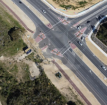
Land Mapping/Surveying
Using automated drone technology it is possible to create a detailed 3d model of both a large area of land as well as the ability to scan and generate high quality models of sites/buildings.

Remote Inspections
In hard to reach places such as power lines, rather than sending out a crew to inspect infrastructure it is easier and more cost effective to deploy a drone to capture high quality images.
Services
Capture stunning aerial shots with Swift Drone Photography. We offer competitive prices tailored to your needs.

Distance Cost
$0.50 per kilometre from Alkimos, Southern Cross or Hopetoun (whichever is closest). Get high-quality drone photography at affordable rates.

Per Photo
Enhance your project with our professional drone photos at just $20 per photo. Perfect for showcasing properties or events.

Labelled Photo
Add value to your photos with labels for easy identification at $25 per photo. Ideal for mapping or inventory purposes.


Contracting Inquiry Form
Servicing both Perth and Rural Western Australia throughout the Wheatbelt and Goldfields
0478477557


